


Australia's East To Shiver Some More, With Widespread Snow Inbound; China Commissions New Icebreaker; WHOI To Start Risky Ocean Geoengineering Experiment Next Month; + Shifting Baseline Syndrome
As always, real-world observations provide a more accurate picture than broad, generalized theories.

Australia's East To Shiver Some More, With Widespread Snow Inbound
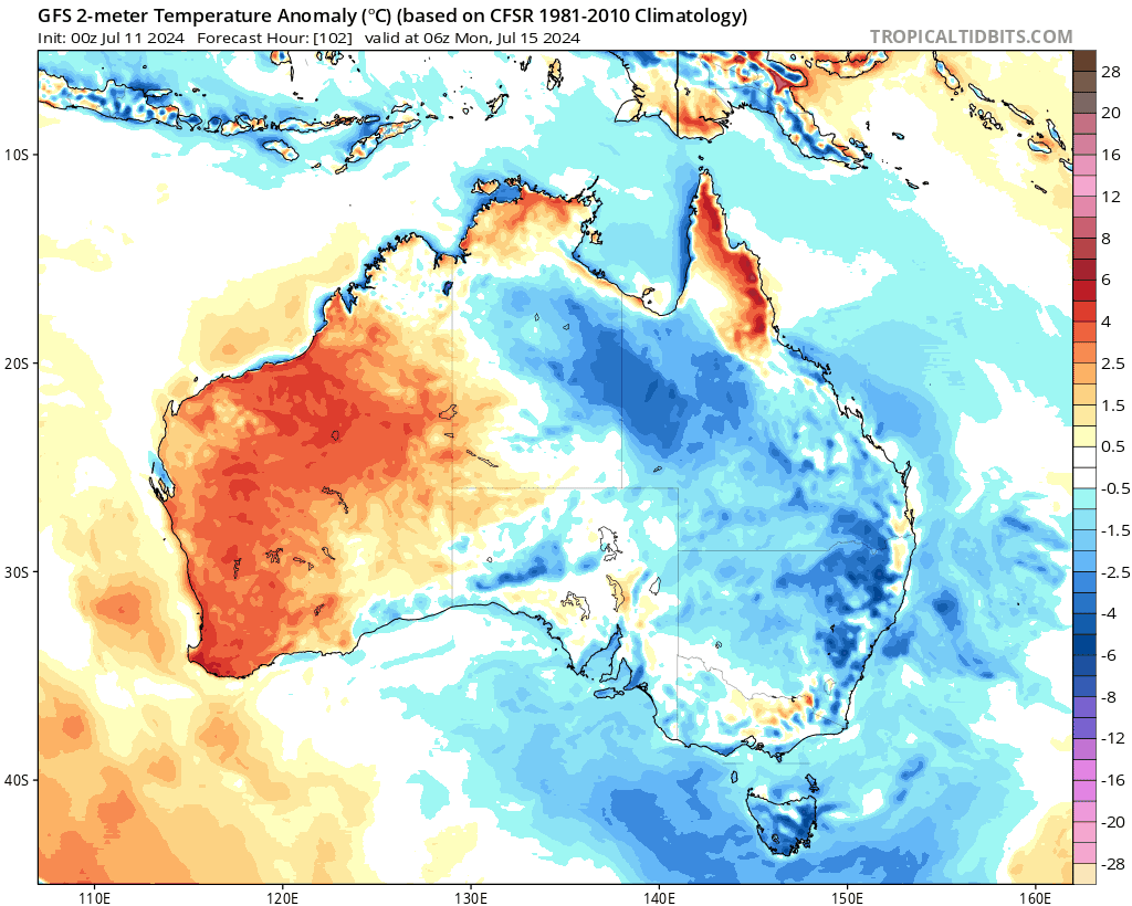
Eastern Australia has been enduring a persistent, record-setting cold for weeks, and a new polar front is forecast to bring snow to large parts of the southeast next week.
Millions of Aussies are bracing for further frigid conditions commencing this weekend, as fresh polar winds ride north from Antarctica—which itself is currently enduring lows of sub -75C (-103F) at the likes of Vostok.
Sky News Australia Meteorologist Alison Osbourne noted that theme for Victoria, NSW, and Queensland will continue to be below-average cold. "A low-pressure system is deepening and cradling across the southern Tasman, while a high-pressure system remains slow-moving in the southern ocean," she explained. "Strong, cold southerly winds will bring plenty of wet weather."
By next Tuesday, 'blues' will have engulfed Eastern Australia, bringing chilling single-digit temperatures even in the afternoons. Southern Queensland, including the Darling Downs and Toowoomba, is preparing for its coldest days in years.
The Sunshine State might even see rare snow by Wednesday, while the Alpine regions of SE Australia are all-but guaranteed heavy snow next week, with accumulations also expected across the lower-elevated regions of NSW, Victoria, and Tasmania.
The Blue Mountains, the Southern, Central, and Northern Tablelands of NSW, elevated parts of the ACT, parts of Victoria outside the Alps, Tasmania outside mountainous areas, and even the Granite Belt of southern Queensland will all likely experience snowfall.
Weatherzone meteorologist Felix Levesque sees flurries in the Tablelands as early as Sunday night, with increasing snow through Tuesday. The snow level could drop below 1,000 m (3,280 ft) midweek, with snow hitting the Barrington Tops NW of Newcastle.
Antarctic air will drive single-digit daily highs to large areas, and south-easterly winds will push this cold air mass across much of the country, prolonging the snowy outbreak through next week.
A high-pressure system following the cold front will then keep much of eastern Australia in a prolonged cold spell, with temperatures remaining well-below historical norms for some time.
The NOAA HYSPLIT model output shows the backward trajectories of air masses ending on July 17, 2024.

The chart traces air masses from different altitudes (500 m, 1000 m, and 5000 m) back six days, revealing their origins over the Tasman Sea and New Zealand.
The model indicates a deep and high-amplitude airmass moving southeast to northeast, expected to deliver polar air mass as far north as SE Queensland, which would prove a notable event, possibly resulting in rare snows and record lows.
China Commissions New Icebreaker
China's new polar research vessel, the Jidi (“Polar”), has been officially commissioned by the Ministry of Natural Resources, capable of breaking through one meter thick sea-ice. This advanced vessel is equipped with drones, unmanned ships, and underwater autonomous robots.
Keep reading with a 7-day free trial
Subscribe to Electroverse Substack to keep reading this post and get 7 days of free access to the full post archives.