
Greenland Still Gaining; June COLD Records From Illinois To The West; Brussels Blames The Air Conditioner; + High-Energy Seismic Week
The mainstream explainer for the heat, however, is not the omega block. Not the missing dust. Not urban heat. Not poor station siting. It is CO2 - specifically this time around, the 'air conditioner'.

Greenland Still Gaining
Greenland’s melt season still isn’t behaving.
The DMI’s latest June 28 update shows fresh, impressive surface mass balance gains across the south and southeast interior.
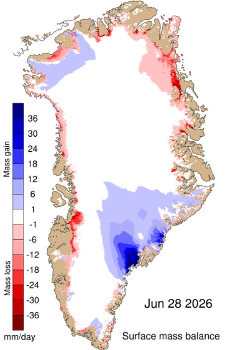
This season’s accumulated SMB is holding near 600 Gt — very high for late June, above the 1981-2010 mean:
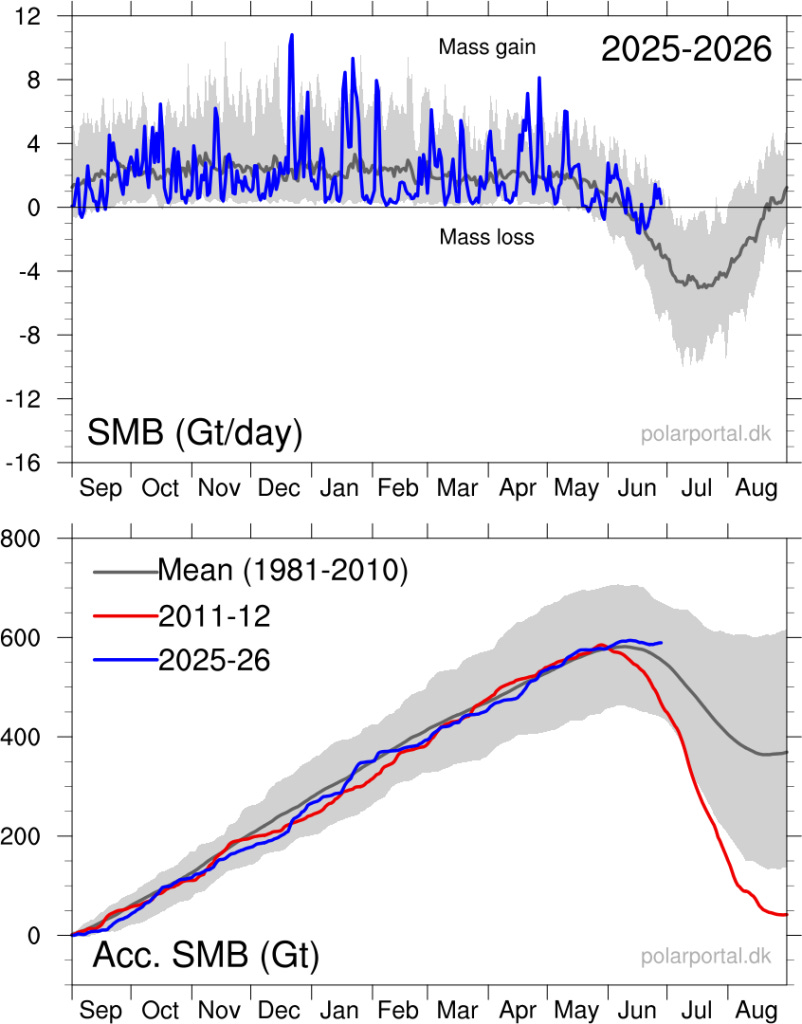
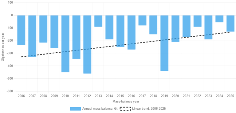
2025-26 set to continue the recent recovery trend seen in GRACE annual mass-balance data:
The wider polar setup remains awkward, too.
The High Arctic has opened melt season historically cold, with temperatures consistently at the bottom of the DMI range. Antarctica’s interior, meanwhile, remains locked in brutal winter cold, with the South Pole recently back below -70C (-94F).
Late June. Calendar summer. Greenland still adding surface mass.
June Cold Records From Illinois To The West
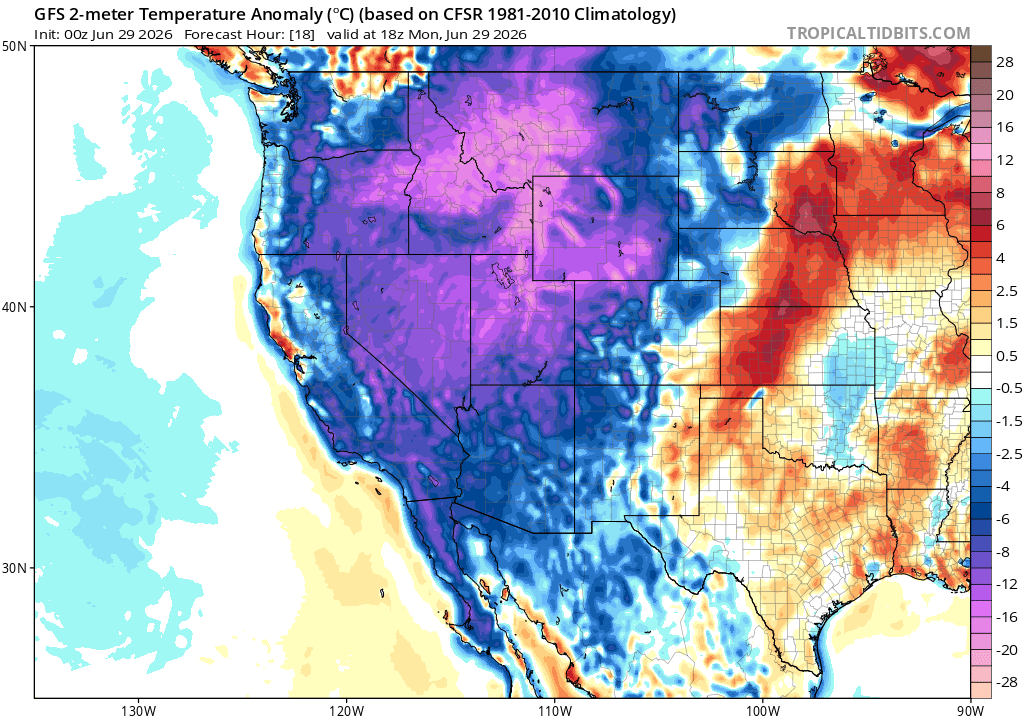
Late June is delivering another cold shot across large parts of the U.S., and records are already falling.
Last Friday, Illinois logged a trio of record-cold highs. Lincoln reached just 68F (20C), breaking the 70F (21.1C) from 1938 and 1926. Peoria tied its record cold maximum of 68F, last set in 1968. Springfield tied its 71F (21.7C) record from 1883 and 1926.
Then the cold shifted west.
At Dillon Airport, Montana, the high on June 28 managed just 45F (7.2C). The NWS says that is a record cool maximum for the date, comfortably besting the old 57F (13.9C) mark from 1959 (books here began in 1929).
Burns, Oregon fell to 33F (0.6C) on the same morning, matching the mark set in 1947.
This system is far from done. The same western trough remains dug in. NWS Boise has southwest Idaho and eastern Oregon running 15F below average, with some 3 inches of snow possible above 7,500 ft in the central mountains. Pocatello reports snow already observed down to 7,000 ft, with more forecast above the passes and frost/freeze conditions in the valleys.
The cold reaches well beyond the Northwest. Phoenix’s office calls the late-June setup unusually cool, with mid-level heights near the 3rd to 10th percentile of climatology and desert highs running 10F below normal.
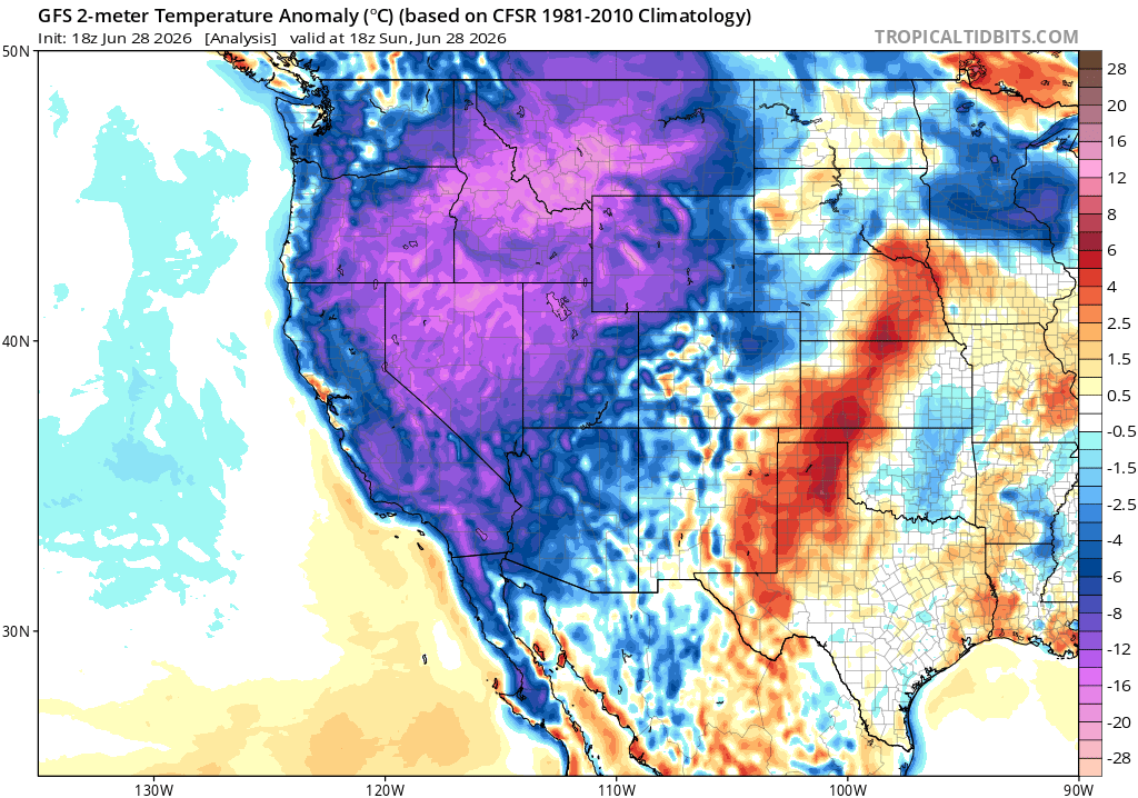
Headed north, Alaska is in the trough too. NWS Fairbanks has a cold front, high-elevation snow in the Brooks and Alaska ranges, a snow/freezing-rain advisory near the Beaufort coast, and colder unsettled conditions lasting through the week, at least.
Western Europe has its heat dome. The American West has June snow, frost and overall sharp anomalies.
Brussels Blames The Air Conditioner
Europe’s heatwave is real. Records have fallen. Roads, rails, schools, hospitals and power systems have strained. But the setup is weather: an omega block, high pressure trapped between lows, sinking air, clear skies, weak ventilation and a late-June sun.
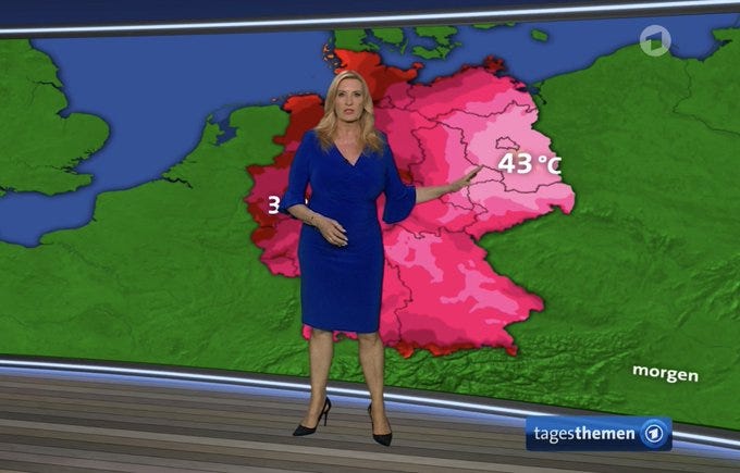
Despite the perfect conditions, the 43C/44C Germany hype did not arrive.
The national record was edged upward slightly to a reported 41.7C (107.1F), not blasted into a new climate regime.
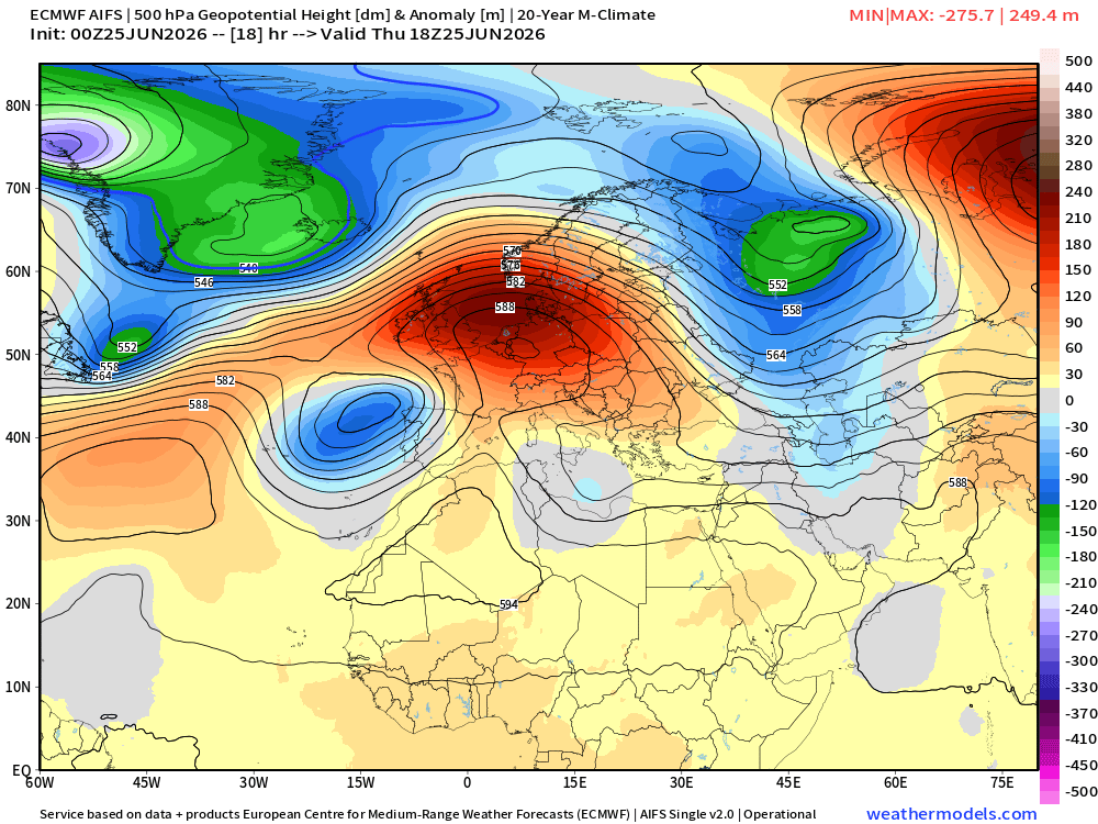
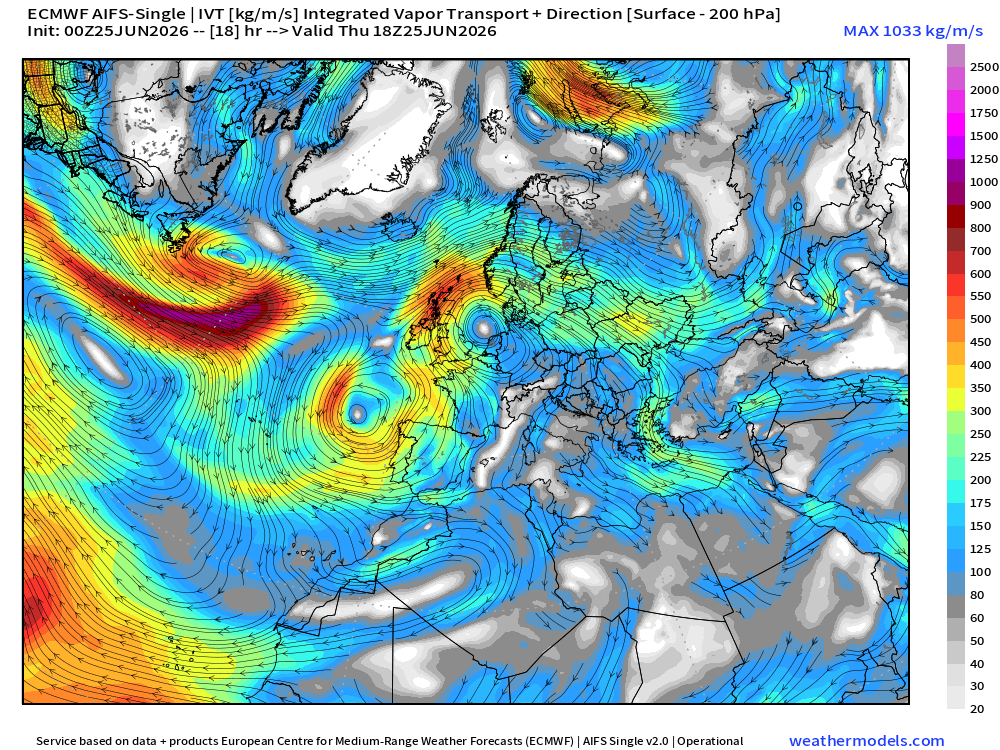
The mechanism: an omega block over western Europe, a cut-off low west of Portugal, and unusually clear air over the continent.
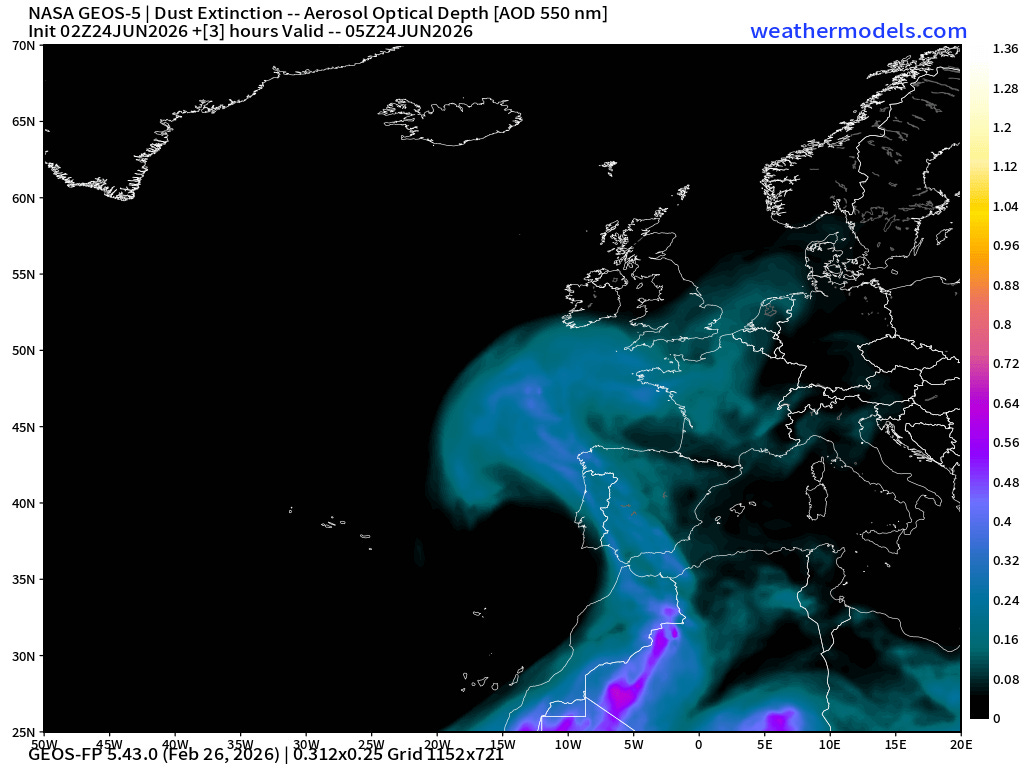
The low helped collect much of the Saharan dust that normally hazes European skies, leaving more solar radiation to hit the surface and feed the heat dome:
Weak Atlantic subtropical moisture added further diabatic support, releasing heat into the ridge and helping intensify it:
The mainstream explainer for the heat, however, was not the omega block. Not the clear air. Not the missing dust. Not urban heat. Not poor station siting. It was CO2 - specifically this time around, the air conditioner.
