


Mumbai's Lowest Temp In A Decade; Northern Hemisphere Cold; Solar Storms Are Possessing Tractors; + The Amazon Rainforest Is A Cloud Machine
The COLD TIMES are returning... Russia approaches -50C (-58F).

Mumbai's Lowest Temp In A Decade
Winter's icy grip continues to tighten across India, with temperatures tanking and snow blanketing northern parts.
Mumbai has just shivered through its coldest December morning in 10 years, with the Santacruz observatory recording a teeth-chattering 13.7C (56.7F), which is 5.1C (9.2F) below normal. The cold is expected to persist for a few days before easing slightly.
Elsewhere, Delhi woke to anomalous 8.2C (46.8F), with light showers adding to the chill.
In the north, Himachal Pradesh glistens under its heavy snowfall of the season. The likes of Shimla, Kufri, and Fagu have been blanketed, with the higher-altitude areas of Lahaul-Spiti and Chamba registering totals in the feet.
Temperatures continue to crash up high, with Tabo posting -13.1C (8.4F) and reporting travel disruptions due to icy roads.

Similarly in Jammu & Kashmir, the cold wave has deepened, with fresh snowfall driving Gulmarg’s temp to -9C (15.8F). Sub-zero conditions prevail across Srinagar and Pahalgam as well, with the region bracing for even harsher cold, as per official forecasts.
Temperatures across the north are expected to drop by another 4C in the coming days.
India’s winter shows no signs of abating.
Northern Hemisphere Cold
Russia
Winter is deepening across Russia also, with the country grappling with some of its most severe December temps in years.
Siberia's Sukhana region has just hit -49.5C (-57.1F), marking the Northern Hemisphere's coldest reading of the season so far outside of Greenland — a freeze attributed to a fierce Arctic air mass sinking south, aided by clear skies/calm winds.
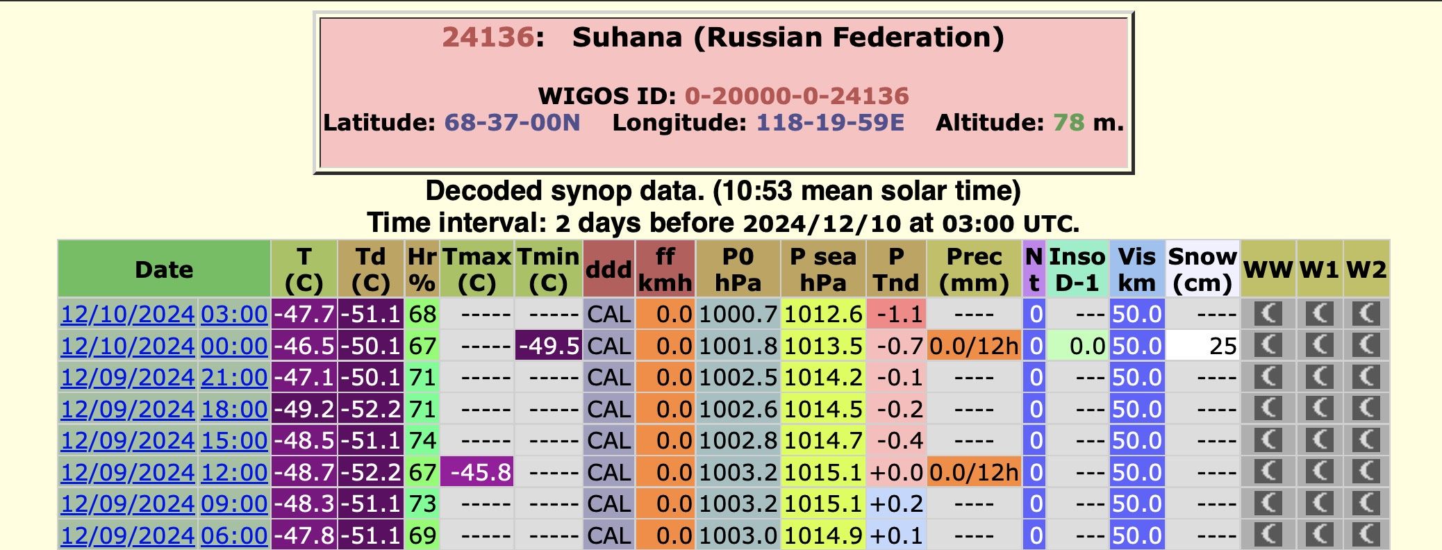
While notably severe for the month of December, this reading doesn't surpass the historical record. That title remains with Oymyakon, another Siberian locale, which hit -61.1C (-78F) in 2021 — Russia's coldest December temperature since 1984.
The outlook calls for an intensification of the cold as the month progresses, meaning that record could be challenged.
Europe
Europe, particularly northern parts, are enduring relentless surges of polar air, owing to a buckled jet stream that is driving down powerful low-pressure systems, bringing heavy snow and frigid temps.
Eastern Europe is shivering too, thanks to a Siberian High spreading stable yet brutally cold conditions over areas like eastern Turkey. This Continental Polar Air Mass is already sending thermometers well below freezing here, with much more to come.
Even in the eastern Mediterranean, a blocking high is locking weather patterns in place, preventing milder air from entering.
In a nutshell: Northern Europe endures wintry storm after wintry storm, while southern and eastern regions remain cold and static. This will be the story for the next few days; that is, until the high breaks, and the north's snow returns down south:

North America
Starting in Canada, an Arctic air mass is sweeping the country this week, plunging nearly every region into deep winter conditions. Temperatures will plummet well below seasonal norms, with only parts of British Columbia escaping.
Keep reading with a 7-day free trial
Subscribe to Electroverse Substack to keep reading this post and get 7 days of free access to the full post archives.